Overview
The Avon (Otakaro) River twists and turns through Christchurch City. The river is a significant part of the local landscape both culturally and ecologically. Fed from springs in the appropriately named Avonhead suburb in the western suburbs to the Avon-Heathcote Estuary (Ihutai). The Avon catchment covers 89 square kilometres of the city, with many tributaries feeding into it. The river has a large diverse ecological base which has changed significantly since early human involvement. Low shrubs and grasses dotted the areas around the river with water tolerant plants such as raupo and flax (harakeke) occupying the banks. Podocarp Forests also thrived in the drier areas. With human development the river has added European exotics such as willows and European grasses with the aim of the original plantings to develop a quintessential English river scape. The river is home to a variety of aquatic animals and birds and other fauna that uses the river for a source of food and shelter. Native birds like the Grey duck, Pukeko and Putangitangi (Paradise Duck) feed along the river and Inanga, Kokopu (native trout) and Eels swim the river. Introduced brown trout, swans and Mallard ducks now also live in the river. The river has strong cultural ties historically as a place to gather resources at sites such as Purai Pā and Ō -Tautahi, which is where we get the namesake of the city Ōtautahi, meaning ‘place of tautahi’. The early European settlers also took to the river developing the banks to look more like an English countryside. Points of note along the banks are Victoria Square formerly known as Market Square occupy the old site of Puari Pā. Other points of interest are the Bridge of Remembrance and Canterbury Earthquake Memorial National Memorial. The beauty of the riverscape compliments the cityscape, giving a stark contrast and a connection to the land Christchurch City is founded on.

Geology
|

Ecology
|

Culture
|

Overall schematic of land types from New Brighton Beach to the Christchurch Airport. Lucas Associates.
Geography
Christchurch City sits on a floodplain that formed in the Late Pliocene-Early Pleistocene. Stretching from the foothills of the Southern Alps to the sea. The floodplain and most of the coastal areas are comprised of post glacial fluvial channel and floodwater sediments known as the Springston Formation. The extension of the floodplains to Banks Peninsula and their interaction with the coast mixed these deposits greatly and forced the Waimakariri River to move back and forth across the area that is now Christchurch City. Combined with the post glacial sea level rise that pushed the coastline inland considerably. The coastline then began to extend out into the ocean again, 5000 years ago the coastline sat on Cathedral Square.
The Otakaro sites inside the Avon Catchment are fed from multiple springs on the eastern side of the city. The catchment covers 89 square kilometres of the city and extends 26 kilometres from the springs to the estuary. These springs are fed through ground water in the Riccarton Gravel deposit. The springs Wairarapa, Waimairi, Orakipaoa are the main suppliers of water to the Avon River.
The Otakaro sites inside the Avon Catchment are fed from multiple springs on the eastern side of the city. The catchment covers 89 square kilometres of the city and extends 26 kilometres from the springs to the estuary. These springs are fed through ground water in the Riccarton Gravel deposit. The springs Wairarapa, Waimairi, Orakipaoa are the main suppliers of water to the Avon River.
Ecology
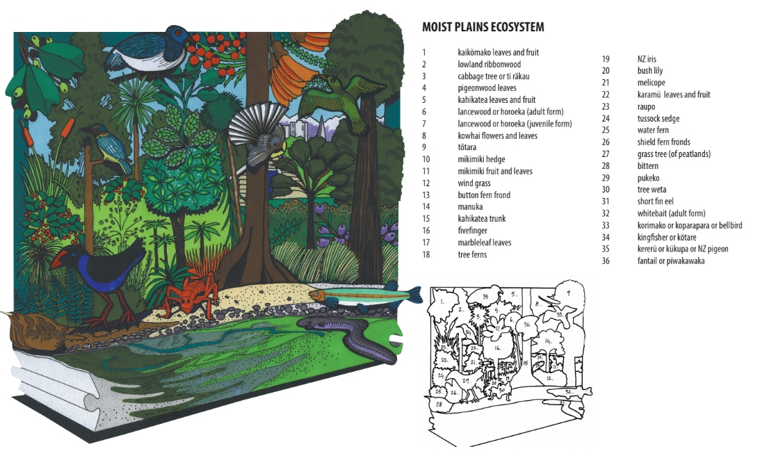
The historical banks of Otakaro consisted largely of water-tolerant species such as raupo, flax, tussock sedges, rushes and cabbage trees. In slightly drier areas up from the bank podocarp forest type was dominant. The small areas of podocarp forest consisted of Kahikatea and Matai with an under-brush of smaller trees and shrubs, which also included the flax, sedges and rushes found closer to the waterways.
The present-day banks of the Avon consist of a mix of native tussock sedges, flax and cabbage trees with the imported European exotics of willows, oaks and flag irises. The exotic plants were imported to create an English landscape for the river. They are being phased out to stop them strangling the river, with more native plants replacing them.
Historically Otakaro was home to a vast array of animals. In the river Inanga and Kokopu (native trout) as well as Shortfin and Longfin eels. Common bully and Giant bully also roamed the river. On the banks Pukeko, putangitangi (Paradise duck), Grey duck, Weka and Grey teal would live in and around the Avon and its tributaries. As well as the forest birds in the upper reaches of the Avon.
In the present-day the Otakaro fauna has struggled to adapt to the radically new urban environment. With generally low aquatic species diversity, and the pollution resistant dominating the environment. This also includes the introduced animals like Brown trout and the Mallard duck. The native Shortfin and Longfin eel, Inanga, Bluegill bully still occupy the river as well as Kakahi, a freshwater mussel. These species are of conservation interest in the river.
Lucas Associates
Culture
The first time the river held any significance to people was Puari Pa, built by the early Maori iwi Waitaha. Occupied between 11th to 16th centuries. The early Waitaha settlement extended north to present day Bealey Avenue. The loop in the river was an important mahangi kai site for gathering large amounts of Tuna (eels), Inanga and Kokopu. An associated urupa (burial ground) was located south at the junction of Cambridge Terrace and Hereford Street.
The namesake of the city, Ōtautahi is named after Te Potiki-Tautahi. Te Potiki-Tautahi can be traced back to one of the chiefs of the Ngai Tahu iwi that travelled in their great ocean-going waka Te Waka Orurea. He died at the site and Ō -Tautahi, the “place of Tautahi” would be adopted as the general name for Christchurch in the 1930’s. Prior to this Ngai Tahu referred to the area Christchurch resides as Karaitiana. The old site of Puari Pa was used by Ngai Tahu as an important mahangi kai site as well and Ngai Tuahuriri would sell produce grown at Tuahiwi to the early settlers. Ngai Tahu used the sites around the river from the 16th century onwards until European settlement.
The early settlers of Christchurch quickly developed the city to replicate a typical English riverside town. With the move away from a resource gathering site of Ngai Tahu it has been replaced by a rapidly growing English river town with the addition of Market Square, Bridge of Remembrance and the Antigua Boat Sheds. In more recent history the river has been used and maintained to compliment the cityscape while attempting to give life back to the river system for the benefit of not just the people who live here but also the wildlife.
The Canterbury Earthquake in February 2011 devastated not just the river but the people living around it. Situated on the Oxford Street side of the river between Durham Street Bridge and Montreal Street Bridge, the Memorial Wall is sat opposite the Memorial Garden on the north bank of the river. All 185 names of those who died are inscribed on the wall, in remembrance of those lost in the earthquake.
